The Ravenna Cosmography is a medieval work of geography that is one of the few such undertakings of the Middle Ages. Most people think it can be dated to the late 7th, early 8th century, probably about the years 650-750. It was created by an anonymous drafter, probably a monk, in the, yes you guessed it, the Italian city of Ravenna.
Now, Ravenna itself is an interesting place and was an even more interesting place back in the medieval day. It became the capital of the Western Roman Empire in 402 and continued as such after the Empire’s collapse, i.e., it was the capital of the kingdom of Odoacer until his execution by Theoderic (who apparently killed Odoacer himself at a peace celebration) in 493 and remained the capital of the Ostrogothic Kingdom until its collapse in 553 when it was recovered for the Eastern Roman Empire by Justinian (or more precisely by Belisarius for Justinian), as was described in the Gothic War by Procopius. It was here at Ravenna at the court of Theoderic that Cassiodorus supposedly wrote his Gothic History which later served as the model for Jordanes’ own version of Getica.

After 553, the city and central Italy remained in Byzantine hands, just barely, pressed on all sides by the Lombards. Formally, the territory was called the Exarchate of Ravenna and it continued in that form until 751 when the Lombards decided to kill Eutychius, the last Exarch. The Pope called in the Franks who then drove out the Lombards and gave (Pippin the Younger at Quierzy) Ravenna to the Popes creating the seed of the Papal states. Later the Franks, under Charlemagne took a significant amount of treasure and artifacts back to to the Carolingian capital of Aachen (which, presumably, is where one ought to look for Cassiodorus’ lost works – or Ravenna – or Constantinople).
In any event, in the Cosmography, the anonymous geographer (cosmographer?) divides the world into sections based on the hours of a clock, i.e., dividing the world into twenty four hours. The twelve hours constituting European parts begin with (this is all in Book I):
- Hour 1 – Western most slice containing western Germania, its dominant Franks as well as the Brits;
- Hour 2 – then we come to Germania of the Frisians;
- Hour 3 – then to Saxony;
- Hour 4 – the Northmen, Denmark, the Alps being the country of the River Elbe where the Maurungani dwelt previously (?), Datia minor and major (?), then Gepidia where now the Huns live (i.e., the Avars), then Illyria/Dalmatia;
- Hour 5 – here live Sciridifrinorum (Sciri?) vel Rerefenorum (?);
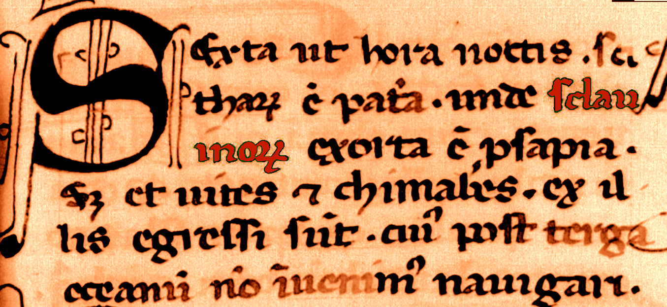
- Hour 6 – finally, brings us to our friends the Slavs:
“Sexta ut hora noctis Scytharum est patria, unde Sclavinorum exorta est prosapia; sed et Vites et Chimabes ex illis egressi sunt. Cuius post terga Oceanum non invenimus navigari.”

1688 Placido Porcheron edition
“The sixth hour of the night is the country of the Scythians, wherein arose the people of the Slavs; And from them there came the Vites and Chimabes, in the back of whom the ocean becomes not navigable.”

- Hour 7 – is the hour of the Sarmatians and of the Carpi (from whom the war went out (?));
- Hour 8 – is where the Roxolani originated and the ancient Scythians on some island (?) called by Jordanes Scanza (!) prior home to Goths and Danes and Gepids (?);
- Hour 9 – is where the Amazons are;
Etc, Etc.
In Book IV, a more specific description of Europe follows. This too is shown in multiple parts, as follows (East to West, roughly):
First, we have Scythia/Khazaria; then Abasgia (Abkhazia) – home of the Alans; then Licania Bosforania on the Black Sea; then comes part IV which says more or less the following:
“Item ad partem septentrionalem iuxta Oceanum confinalis praefatae maioris Scythiae ponitur patria quae dicitur Colchia Circeon, Melanglinon, Bassarinon. Quae Colchia Circeon in omnibus eremosa esse dinoscitur. De qua patria enarravit Pentesileus philosophus. Item iuxta Oceanum confinanlis praefatae regionis Colchiae est patria quae dicitur ab antiquis Amazonum, postquam eas de Caucasis montibus exisse legimus. De qua patria subtilius agunt supra scriptus Pentesileus et Marpesius atque Ptolomaeus rex Aegyptiorum Macedonum, philosophi. Item iuxta Oceanum est patria quae dicitur Roxolanorum, Suaricum, Sauromatum. Per quam patriam inter cetera transeunt flumina quae dicuntur, fluvius maximus qui dicitur Vistula, quia nimis undosus in Oceano vergitur, et fluvius qui nominatur Lutta. De qua patria enarravit supra scriptus Ptolomaeus rex et philosophus. Cuius patriae post terga infra Oceanum supra scripta insula Scanza invenitur.”
Which, roughly, means that in the North near the Ocean, Greater Scythia continues and we have various other countries, including the country of the Amazons, then also near the Ocean the country of the Roxolans, Suaricum (of the Swedes?) and Sarmatians. Through that country passes the River Vistula and also the River Lutta (?). All of this corresponds to the above hours 9, 8 and 7.

Then in part V, we have the countries in front of Roxolania, e.g., Sithrogorum, Campi Campanidon (?), Getho Githorum, Sugdabon, Fanaguron and what appears to be the Maeotian (Mursian?) Swamp. Parts VI through X are rather uninteresting (Thrace, Moesia and Greece) and then we get to part XIV and learn about, among others, Dacia aka Gepidia where now the Avars live. Further, we have a discussion of Carnech country (Julian Alps as attested by Marcomirus, the Gothic philosopher) which presumably means Carinthia. We also get to Gallia which has such rivers, among others, as Saruba (Zaruba = Zaręba = a place where bushes were cut down or, maybe, something about Sorbs, Serbs?, today: Saravus), Bleza (today: Blies), Nida (today: Nied), which, at the Rhodanus (hmmm… Rodan?), also include Duba and Saganna, etc. Then in the Venetian provinces we have rivers such as Sile (today: Silis) and Plave (today: Piave) and so it goes. In Portugal we have towns such as Mirtilin, Besurin, Serpas (some continue to be there to this day! Are the Sueves responsible for these names?).
Now, take a look at the above and look at the map that was put together for an edition of the Cosmography (above). Isn’t it strange that the sixth hour where the Slavs are does not contain the River Vistula (which is, in effect, in the seventh or maybe even (as per the above picture), the eight hour)? Who is on the Vistula? Roxolani, Suarices (!?) and Sauromates.
(Now, the Suavi, with an “-a”, are listed separately (from the Sclavins listed in Book IV) but in an area roughly corresponding to the third hour and hence the person who drew the above picture places them in that general area).
(There are three manuscripts of the Cosmography, all significantly removed from the autograph, and none seems readily available so we use here “relatively recent” printing from 1860 that is more easily available. The manuscripts are the Codex Vaticanus Urbinas 961, Codex Parisinus Bibliotheque Imperial 4794, Codex Basiliensis F.V.6.)
Copyright ©2015 jassa.org, All Rights Reserved
Pingback: On Thietmar & Hennil | In Nomine Jassa
Pingback: Alfred’s “Orosius” & Its North European Geography | In Nomine Jassa